Sumner Point Anchorage
A hurricane-protected harbour on Rum Cay's eastern shore offering exceptional diving access and dramatic development ruins.
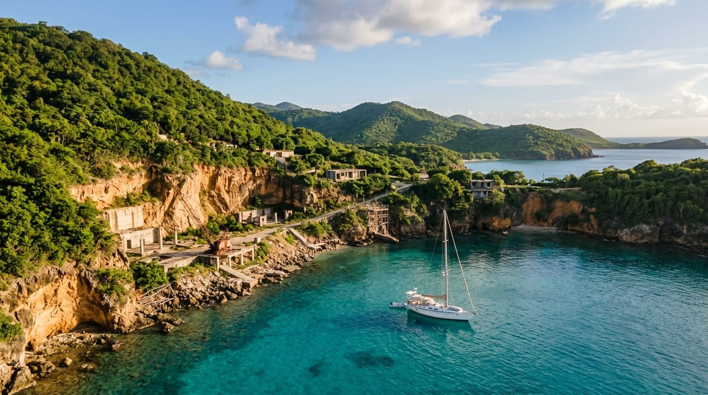
Sumner Point occupies Rum Cay's eastern shore, where an ambitious marina development once promised to transform this remote island into a yachting destination. While the marina itself no longer operates, the harbour retains its natural protection from most wind directions, offering cruisers a secure alternative to the more exposed Port Nelson anchorage on the island's southwestern side.
The dramatic ruins of the abandoned Rum Cay Marina development add an otherworldly atmosphere to this already remote destination. Massive excavations for the planned harbour basin remain partially completed, creating a surreal landscape that contrasts sharply with the pristine natural beauty of the surrounding waters.
Approach and Navigation
Sumner Point lies on the eastern side of Rum Cay, accessed via the deep water surrounding the island. The approach is relatively straightforward in good visibility, with the harbour opening identifiable as you round the island's eastern shore.
The inner basin of the former marina development has a control depth that once accommodated vessels to 12 feet at low tide, though conditions may have changed since operations ceased. Navigate by eye and verify depths before committing. Consult fellow cruisers and current cruising guides for up-to-date information on entrance conditions.
Holding and Protection
The harbour at Sumner Point was designed to provide protection from all wind directions except the south. Natural geography and the harbour's orientation shelter vessels from the predominant easterly trades, while the landmass of Rum Cay blocks northern and western exposure.
Holding in the harbour area is good in sand, though the development work may have altered bottom conditions in some areas. When southerly winds or swells are forecast, consider relocating to more protected options or heading to Port Nelson, which offers different exposure characteristics.
What's Ashore and Nearby
The abandoned marina development dominates the Sumner Point landscape. Massive excavations for what was to be a large yacht basin remain partially completed, creating dramatic artificial cliffs and pools. The scale of the failed project is both impressive and cautionary, a monument to ambitious development in these remote waters.
Rum Cay's exceptional diving lies within easy reach of Sumner Point. The island's position in deep water means spectacular wall diving and outstanding visibility. Historic wrecks and vibrant reef systems attract serious divers, while snorkelers find plenty to explore in shallower areas.
Cruising Considerations
The marina at Sumner Point is permanently closed and no services are available. Fuel, water, and provisions must be brought from elsewhere. The nearest settlement is Port Nelson on the island's western side, a walk or dinghy ride away.
The harbour's protection makes it worth considering for vessels planning extended stays on Rum Cay or those seeking shelter from weather that would make Port Nelson uncomfortable. The eerie atmosphere of the abandoned development adds interest, though some cruisers may find it unsettling. Allow time to explore both the ruins and the exceptional underwater environment.
Getting there
Sumner Point is located on the eastern shore of Rum Cay, approximately 50 nautical miles southeast of Georgetown, Exuma. Most cruisers approach from Long Island, Conception Island, or San Salvador. Round the eastern end of Rum Cay to access the harbour entrance. The approach is straightforward in good visibility. Verify current conditions with fellow cruisers before entering, as the harbour infrastructure has not been maintained since the marina closed.
Frequently asked questions
- Is Sumner Point Marina operating?
- No, Sumner Point Marina closed permanently several years ago and no services are available. The harbour itself remains accessible for anchoring, but there is no fuel, water, electricity, or dockage available. Plan to be completely self-sufficient.
- What happened to the Rum Cay Marina development?
- An ambitious resort and marina development was planned for Sumner Point, with extensive excavation work completed for a large yacht basin. The project failed financially and was never completed. The dramatic ruins of the excavation work remain visible and can be explored.
- Is Sumner Point better protected than Port Nelson?
- Sumner Point offers better protection from most wind directions except south, while Port Nelson is exposed to south and west winds. The choice between anchorages depends on prevailing and forecast conditions. Some cruisers move between the two as weather patterns change.