Pinder's Point
A historic fishing village where the descendants of freed slaves still tend a striped lighthouse guiding ships past treacherous shoals.
Pinder's Point is a string of four connected settlements on Grand Bahama's southern coast, united by a common name and the descendants of the freed slaves who first claimed these lands after emancipation. The Pinder surname — originally belonging to white settlers who owned the area — was absorbed into the community as freed slaves established their homes and livelihoods along this rocky shore.
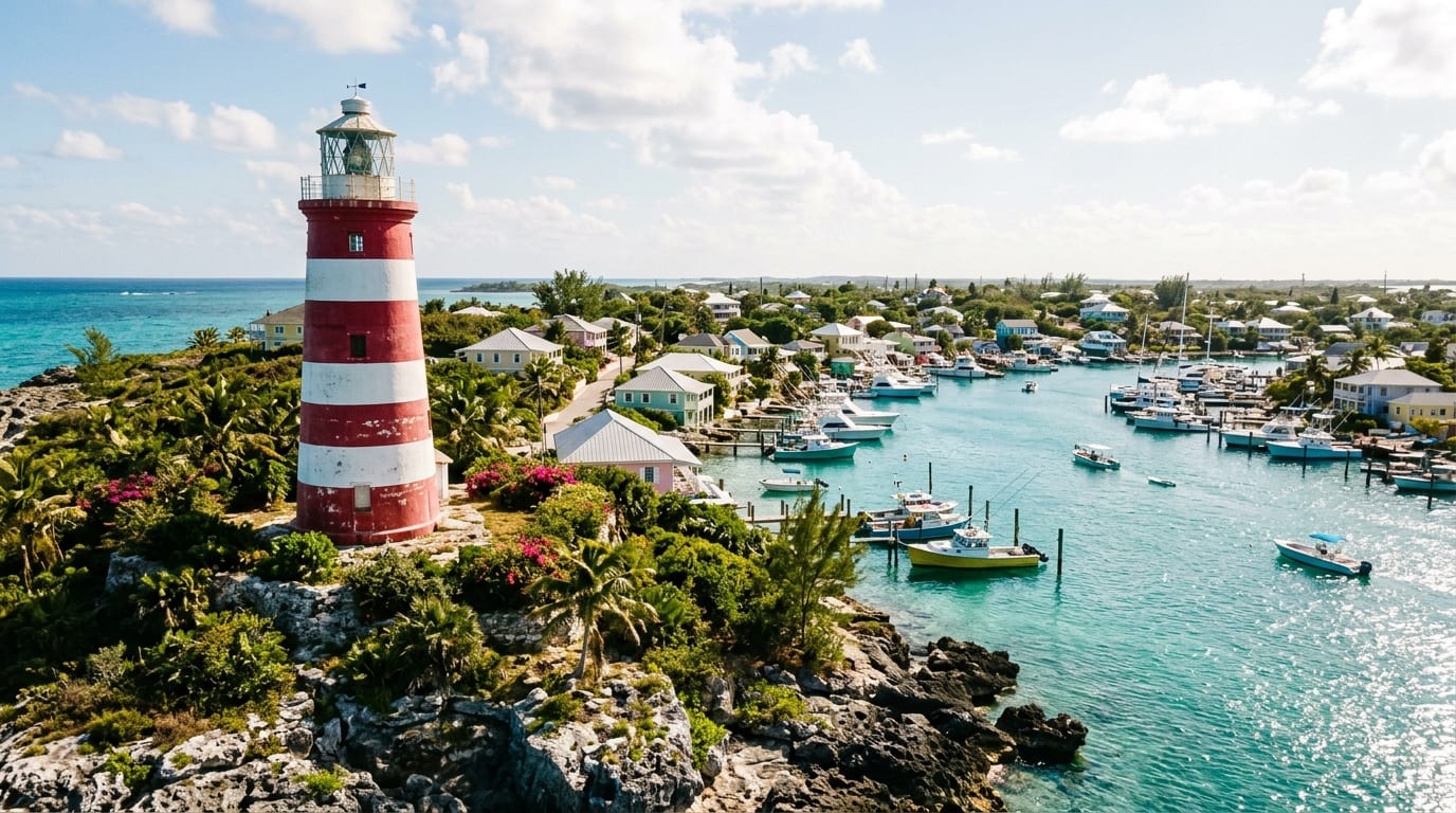
The settlement's most recognizable landmark is its distinctive lighthouse, a 40-foot cinder-block tower painted with three red and three white horizontal stripes. Built in the 1960s when Freeport Harbour was created, it replaced an earlier torch that Samuel Pinder, a community descendant, would light each evening and extinguish at dawn to warn mariners of the treacherous shoals.
The Lighthouse Legacy
Before the modern lighthouse was constructed, navigation around Pinder's Point relied on a simpler system. Each evening at dusk, Mr. Samuel Pinder would climb to the point and light a torch that burned through the night, guiding ships safely past the craggy coastline and dangerous shoals. At dawn, he would extinguish the flame.
The current lighthouse was built in the 1960s shortly after a creek was dredged to create Freeport Harbour. Standing 40 feet tall with its distinctive red-and-white striped paint, the lighthouse continues to serve its original purpose while also becoming a symbol of the community's long connection to maritime life.
Community Heritage
Pinder's Point comprises four subsettlements that grew together over time: the original Pinder's Point absorbed Cooper's Town, and the community expanded along the coast. The Pinder surname became dominant as families intermarried and generations passed, but the community's roots trace directly to the period following 1834 emancipation.
Today, many Pinder's Point families have lived here for generations, maintaining fishing traditions and a close-knit community spirit. The settlement remains deeply connected to Bahamian culture and history, offering visitors a glimpse of authentic island life far from the resort developments of Freeport.
Visiting Pinder's Point
Pinder's Point lies along the southern coast of Grand Bahama, accessible via the coastal road that connects the western settlements to Freeport Harbour. The lighthouse is visible from the road and makes for a worthwhile photo stop, though there are no formal facilities or visitor services.
The community is residential with limited tourism infrastructure, so visitors should be respectful of private property and residents. Those interested in Bahamian history will appreciate the opportunity to see a settlement whose roots stretch back to the earliest days of freedom.
Getting there
Pinder's Point is located on Grand Bahama's southern coast near Freeport Harbour. The settlement is accessible via the coastal road from Freeport, approximately 15 minutes from the Port Lucaya area. A rental car or taxi is required as there is no public transportation serving the community. The lighthouse is visible from the main road and can be photographed without entering private property.
Frequently asked questions
- Can I visit the Pinder's Point lighthouse?
- The lighthouse is visible from the road and you can photograph it from public areas. It is not open to visitors for climbing, and the immediate area is community property. Please be respectful of residents and private land.
- Are there restaurants or shops at Pinder's Point?
- Pinder's Point is primarily a residential fishing community without dedicated tourist facilities. Visitors should eat and shop in Freeport or Port Lucaya before or after their visit.
- How did Pinder's Point get its name?
- The settlement is named after the Pinder family, originally white settlers who owned land in the area. After emancipation in 1834, freed slaves took over the lands and eventually adopted the Pinder surname, which became dominant throughout the community.
Nearby
Rand Nature Centre
A 100-acre sanctuary where native pine forests shelter rare orchids, migratory songbirds, and one of Grand Bahama's most peaceful nature trails.
ExplorePeterson Cay
A tiny one-acre national park rising from the reef a mile offshore, where kayakers and snorkelers discover Grand Bahama's most pristine underwater sanctuary.
ExplorePelican Point
A secluded eastern settlement where pelicans patrol pristine bonefishing flats and the annual Coconut Festival celebrates island traditions.
Explore