West End (Settlement Point)
The historic gateway to the Bahamas where Gulf Stream crossings end and island adventures begin.
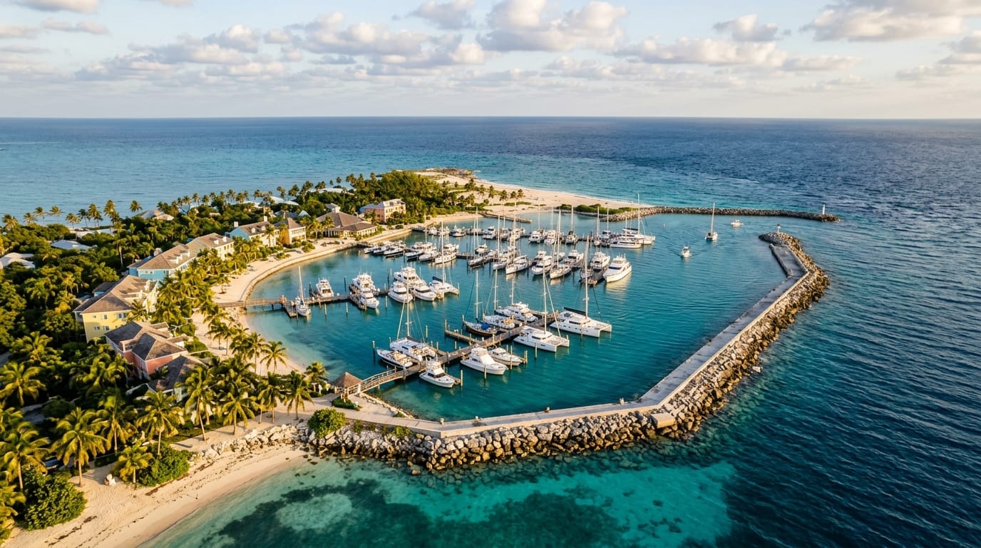
West End, locally known as Settlement Point, marks the westernmost tip of Grand Bahama and serves as the primary landfall for vessels crossing the Gulf Stream from Florida. Just 56 nautical miles from West Palm Beach, this historic fishing village has welcomed mariners for generations seeking shelter after the challenging open-water passage.
The anchorage sits adjacent to Old Bahama Bay Resort and Marina, providing cruisers with options ranging from a protected marina berth to anchoring out in the bight. As an official Bahamas port of entry, West End offers convenient customs clearance for vessels entering Bahamian waters, making it the logical first stop before continuing to the Abacos or exploring Grand Bahama itself.
Approach and Entrance
Vessels arriving from Florida typically approach West End via either the Memory Rock Passage or the Indian Cay Channel. Memory Rock offers deeper water with at least 12 feet throughout, making it the preferred route for deeper-draft vessels despite the longer distance. Indian Cay Channel provides a more direct approach but carries only about 5 feet at low water over a rocky bottom, requiring careful timing with the tide.
From the northwest, the approach to Old Bahama Bay Marina follows a well-marked, dredged channel. The marina's GPS coordinates are approximately 26 degrees 42.189 minutes North, 78 degrees 59.872 minutes West. The controlling depth is 8 feet at mean low water with an approach depth of 13 feet, accommodating most cruising vessels comfortably.
Holding and Protection
The anchorage area lies immediately north and east of the marina entrance, though the usable anchoring space is limited. The suitable area begins roughly 300 yards east of the northeast corner of the marina seawall and extends eastward as draft permits. Bottom composition includes sand with significant grass patches that should be avoided to ensure reliable holding.
Protection is adequate in prevailing easterly through southeasterly winds, with the marina breakwater and adjacent shoreline providing shelter. The anchorage becomes uncomfortable or untenable in strong northerly or westerly conditions, which typically accompany cold fronts during winter months. During unsettled weather, the marina offers a secure alternative with 63 slips.
Services and Provisions
Old Bahama Bay Marina provides full-service facilities including high-speed fuel pumps dispensing both diesel and 92-octane gasoline, shore power, fresh water, and pump-out services. The resort maintains a restaurant, swimming pool, and beachfront amenities accessible to marina guests. Customs and immigration clearance is available at the marina office.
The historic West End settlement lies within walking distance, offering a glimpse of authentic Bahamian village life. Small grocery stores stock basic provisions, though selection is limited compared to Freeport. For more extensive provisioning or marine services, cruisers typically continue to Port Lucaya, approximately 25 nautical miles to the east.
Onward Routing
From West End, cruisers have several routing options. The most common route crosses the Little Bahama Bank toward the Abacos, with Great Sale Cay and Mangrove Cay serving as popular waypoints. This bank crossing covers approximately 60 nautical miles of shallow water averaging 8 to 15 feet, requiring good visibility and settled weather.
Alternatively, vessels bound for Freeport and Port Lucaya can follow the south shore of Grand Bahama, a scenic day sail past undeveloped coastline. The Grand Lucayan Waterway provides a protected shortcut for vessels with less than 27 feet of air draft and suitable ground tackle for the strong currents.
Getting there
West End lies 56 nautical miles east-southeast of West Palm Beach across the Gulf Stream. Most cruisers depart Lake Worth Inlet or Palm Beach Inlet at night to arrive at first light, allowing good visibility for the approach. From Memory Rock, the approach is deep and straightforward. From Indian Cay Channel, time your arrival for high tide if drawing more than 4 feet. The marina monitors VHF Channel 16 and working Channel 68. For vessels already in the Bahamas, West End is approximately 25 nautical miles west of Port Lucaya along the south shore.
Frequently asked questions
- Can I anchor at West End or must I use the marina?
- Anchoring is possible in the bight east of Old Bahama Bay Marina, though usable space is limited. The bottom is mixed sand and grass, so choose a sandy patch carefully. Many cruisers opt for a marina slip, especially after a tiring Gulf Stream crossing, to facilitate customs clearance and access shore power.
- Which approach is better: Memory Rock or Indian Cay Channel?
- Memory Rock Passage is recommended for most vessels as it carries at least 12 feet throughout and presents fewer navigational challenges. Indian Cay Channel is shorter but carries only 5 feet at low water over a rocky bottom, requiring tide timing and careful piloting. Consult Explorer Charts and current cruising guides for detailed waypoints.
- What services are available at West End?
- Old Bahama Bay Marina offers fuel, water, electricity, pump-out, and customs clearance. The resort has a restaurant, pool, and beach. West End village has small grocery stores for basic provisions, but major provisioning should be done in Port Lucaya or before departing Florida.
Nearby
Sandy Cay
A deserted island anchorage for staging Gulf Stream crossings or resting after the open-water passage.
ExplorePort Lucaya (Bell Channel)
Grand Bahama's cruising hub where full-service marinas, world-class diving, and vibrant waterfront dining await.
ExplorePeterson Cay
The Bahamas' smallest national park, a pristine snorkeling paradise just one mile offshore.
Explore