High Rock
Perched on a 30-foot limestone bluff, this eastern settlement offers dramatic coastal views and the administrative heart of East Grand Bahama.
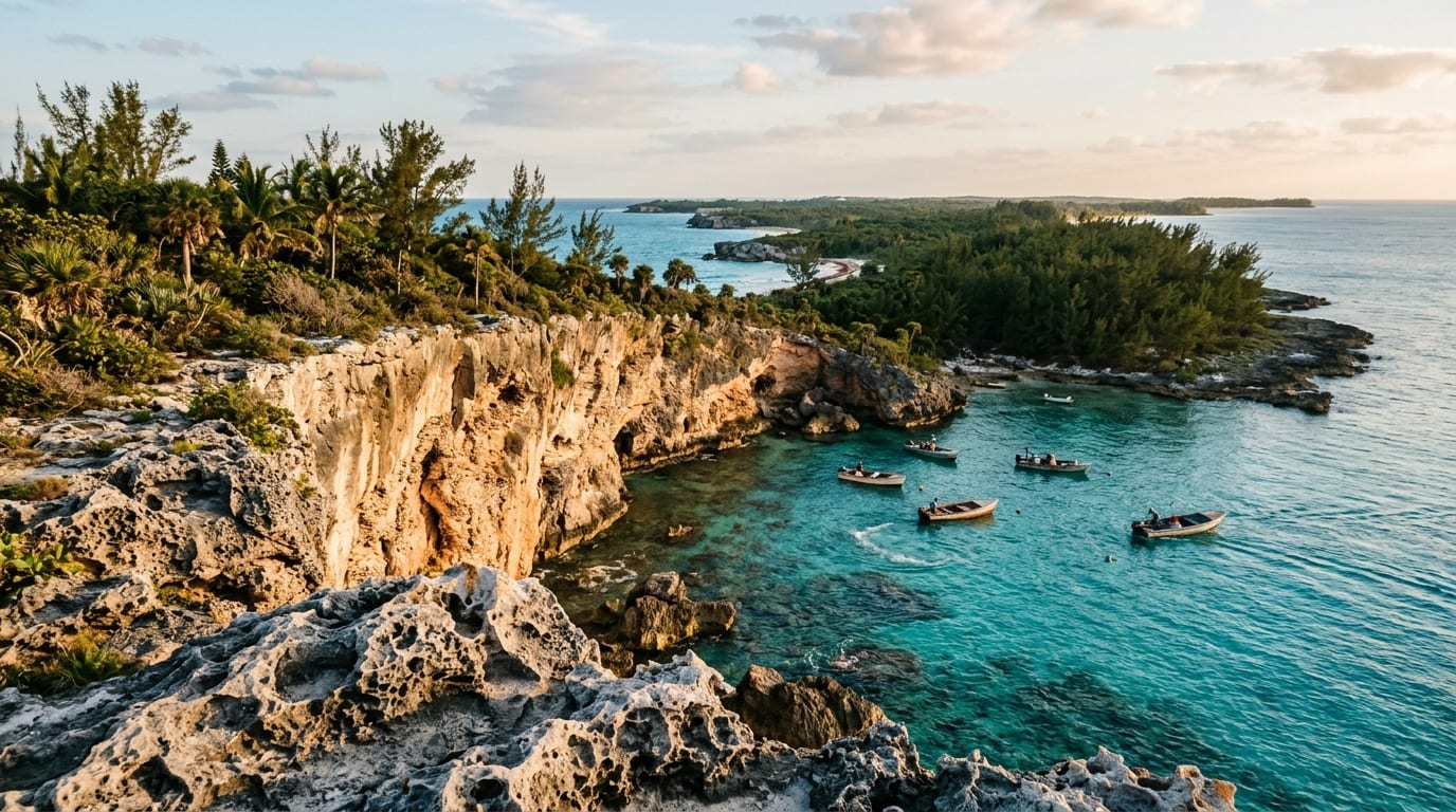
High Rock rises from Grand Bahama's southern shore, a settlement named for the dramatic 30-foot limestone bluff that separates the coastal road from the sea below. This elevated position creates stunning ocean vistas and has made High Rock a natural gathering point for communities along the eastern end of the island.
Serving as the administrative seat for East Grand Bahama district, High Rock anchors a string of smaller settlements that stretch toward the remote eastern tip of the island. Fishing boats launch from protected coves below the bluff, and residents maintain the traditional way of life that has sustained families here since Loyalist settlers arrived after the American Revolution.
The Limestone Bluff
High Rock's defining feature is the limestone escarpment that gives the settlement its name. Rising approximately 30 feet above sea level, this rocky bluff provides sweeping views of the turquoise waters offshore and the reef systems that line this coast.
The bluff is composed of ancient coral limestone, weathered and pitted by centuries of wind and salt spray. At its base, waves crash against rocky outcrops and small beaches nestle in protected coves. The elevated position catches cooling breezes and offers dramatic vantage points for watching storms approach across the Caribbean Sea.
Post-Hurricane Recovery
Hurricane Dorian devastated High Rock in September 2019, making landfall as a Category 5 storm and stalling over Grand Bahama for more than 40 hours. The settlement suffered catastrophic damage, with storm surge and flooding destroying nearly every structure.
In the years since, the community has worked to rebuild. Residents have demonstrated remarkable resilience, returning to restore homes and reestablish the fishing-based economy that sustains families here. The recovery continues, but High Rock is once again home to a living community determined to preserve its heritage.
Fishing Traditions
Commercial and subsistence fishing have sustained High Rock for generations. The waters offshore hold grouper, snapper, and various reef fish, while the flats produce bonefish for visiting anglers. Conch and spiny lobster provide additional income for local fishermen.
The fishing traditions here predate modern tourism on Grand Bahama. Families pass down knowledge of productive grounds, seasonal patterns, and traditional techniques from generation to generation. Visitors who arrange fishing trips with local guides benefit from this accumulated wisdom.
Gateway to the East
High Rock serves as the logical base for exploring Grand Bahama's remote eastern end. The settlement offers basic services and marks the transition from the more developed central portion of the island to the increasingly wild landscape that stretches toward McLean's Town and Sweeting's Cay.
The drive east from High Rock passes through Freetown, Pelican Point, and other small settlements before reaching the end of the road at McLean's Town. The scenery grows more dramatic as you travel east, with pine forests, mangrove creeks, and pristine beaches accessible only to those willing to make the journey.
Getting there
High Rock lies approximately 40 miles east of Freeport along Grand Bahama Highway. The drive takes about an hour through increasingly rural scenery. Rental cars are available at Grand Bahama International Airport. Beyond High Rock, the road continues east to McLean's Town and eventually ends, so a vehicle is essential for exploration.
Frequently asked questions
- Has High Rock recovered from Hurricane Dorian?
- Recovery is ongoing. The community suffered catastrophic damage in September 2019 and continues rebuilding. Residents have returned and are restoring homes and businesses, but the process will take years. Visitors should expect limited services and facilities.
- Is there a beach at High Rock?
- The settlement sits atop a limestone bluff rather than at beach level. Small beaches nestle in coves below the bluff and are accessible from certain points. The coastline is dramatic but more rocky than sandy in many areas.
- What can I see driving east from High Rock?
- The drive east passes through Freetown, Pelican Point, and other small settlements before reaching McLean's Town at the road's end. The scenery includes pine forests, mangrove creeks, and occasional glimpses of pristine beaches. The landscape becomes increasingly wild and undeveloped.
Nearby
Xanadu Beach
A secluded crescent of white sand with echoes of Hollywood glamour and the ghost of Howard Hughes' Bahamas retreat.
ExploreParadise Cove Beach
A palm-fringed snorkelling paradise where Deadman's Reef delivers Grand Bahama's best shore diving within swimming distance.
ExploreLucaya Beach
Grand Bahama's most popular resort beach, where water sports, beach bars, and the Port Lucaya Marketplace meet on soft white sand.
Explore